- text (x)
- Aerial photographs (x)
- Grinnell (Iowa) (x)
- 1940s (x)
- Search results
-
-
Title
-
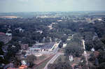
Aerial View of 4th Avenue and State Street
-
Description
-
Aerial photograph looking north from the intersection of 4th Avenue, State Street and the railroad tracks in Grinnell, Iowa, in 1967. Grinnell Motor Company is visible in the center of the photo with Brand Apartments just to the left.
-
Date Created
-
1967
-
PID
-
grinnell:6404
-

-
Title
-
Aerial View of Downtown Grinnell
-
Description
-
Aerial photograph of downtown Grinnell, Iowa, looking north along Broad Street from Central Park in 1967. Many Grinnell landmarks are visible: Merchants National Bank, Cunningham Drug, Stewart Library, the post office, Saint Mary's Catholic Church, the Colonial Theatre, Spaulding House.
-
Date Created
-
1967
-
PID
-
grinnell:6406
-

-
Title
-
Aerial View of Downtown Grinnell
-
Description
-
Aerial photograph of downtown Grinnell, Iowa, looking north along Main Street from approximately 3rd Avenue in 1967.
-
Date Created
-
1967
-
PID
-
grinnell:6407
-
-
Title
-
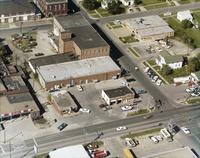
Aerial View of East Street and 4th Avenue 1970s, Aerial View of East Street and Fourth Avenue
-
Description
-
Aerial photo of the intersection of East Street and 4th Avenue in Grinnell, Iowa, in the early 1970s, looking west-northwest. Visible along the bottom of the photograph, from left to right, are Russ's Feed, McCurry Cafe, Pioneer gas station and Fina Fuel. Across the street is the Goodyear parking lot. Also visible are the Spaulding Manufacturing buildings and the the police station. Drake Community Library (Grinnell, Iowa) Archives. Views of Grinnell, Aerial Images. Collection 17-5.
-
Date Created
-
1970
-
PID
-
grinnell:27168
-
-
Title
-
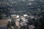
Aerial View of Grinnell College Campus
-
Description
-
Color aerial photograph of the Grinnell College campus looking east along 8th Avenue in 1967. The science building is at the bottom center of the photo. To the right of that is the Men's Gymnasium (called Women's Gymnasium after 1942). The east campus dormitories and Saint John's Lutheran Church are visible near the center of the photo.
-
Date Created
-
1967
-
PID
-
grinnell:6400
-
-
Title
-
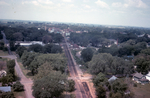
Aerial View of Grinnell Looking West along the Railroad Tracks
-
Description
-
Aerial photograph looking west along the railroad tracks from approximately High Street in Grinnell, Iowa, in 1967. The railroad depot is visible in the center of the picture and just to the right of the depot the Monroe Hotel is visible. The Spaulding smokestack is visible in the background to the left.
-
Date Created
-
1967
-
PID
-
grinnell:6405
-

-
Title
-
Aerial View of Northwest Grinnell
-
Description
-
Aerial photograph of northwest Grinnell, Iowa, looking north along Reed Street from approximately 6th Avenue in 1967. Bailey Park Elementary School is visible at the left center of the photo. The newly completed General Telephone company building is visible in the upper left.
-
Date Created
-
1967
-
PID
-
grinnell:6401
-
-
Title
-
Aerial View of Southwest Grinnell
-
Description
-
Aerial photograph of southwest Grinnell, Iowa, looking southwest in 1967. Davis School on Hamilton Avenue between Broad and Main Streets (with curved driveway) is on the left edge of the lower half of the photo. The trailer park along Washington Avenue is visible in the center of the photo.
-
Date Created
-
1967
-
PID
-
grinnell:6403