- * (x)
- United States (x)
- Grinnell (Iowa) (x)
- Heise, David W. (x)
- Education (x)
- Search results
-

-
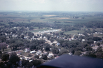
Title
-
Aerial View of Northwest Grinnell
-
Description
-
Aerial photograph of northwest Grinnell looking north along Prairie and Reed Streets. Bailey Park Elementary School is visible at the bottom center of the photo. The newly completed General Telephone company building is slightly above the center of the photo. Sunset Avenue is to the far left and 11th Avenue is the northmost east-west street visible.
-
Date Created
-
1967
-
PID
-
grinnell:6402
-

-
Title
-
Aerial View of Northwest Grinnell
-
Description
-
Aerial photograph of northwest Grinnell, Iowa, looking north along Reed Street from approximately 6th Avenue in 1967. Bailey Park Elementary School is visible at the left center of the photo. The newly completed General Telephone company building is visible in the upper left.
-
Date Created
-
1967
-
PID
-
grinnell:6401
-
-
Title
-
Aerial View of Southwest Grinnell
-
Description
-
Aerial photograph of southwest Grinnell, Iowa, looking southwest in 1967. Davis School on Hamilton Avenue between Broad and Main Streets (with curved driveway) is on the left edge of the lower half of the photo. The trailer park along Washington Avenue is visible in the center of the photo.
-
Date Created
-
1967
-
PID
-
grinnell:6403