- * (x)
- Business (x)
- 1988 (x)
- Kleinschmidt Architectural History (x)
- Photograph (x)
- Montezuma (Iowa) (x)
- Central business districts (x)
- 1990s (x)
- Search results
-
-
Title
-
1003 Main Street
-
Description
-
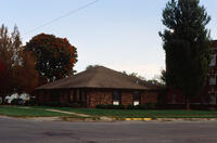
View of the south facade of the offices for Plate Baker & Company at 1003 Main Street in Grinnell, Iowa. Drake Community Library (Grinnell, Iowa) Archives. Martzahn City Planning Slides, p.12, slide 18.
-
Date Created
-
2001
-
PID
-
grinnell:30250
-

-
Title
-
6th Avenue, Sixth Avenue
-
Description
-
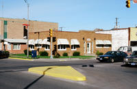
View looking west on 6th Avenue from Broad Street in Grinnell, Iowa. Kelcy's Fine Foods, the Maid-Rite, the Standard station and the Sunoco station are all visible. Drake Community Library (Grinnell, Iowa) Archives. Martzahn City Planning Slides, p.13, slide 10.
-
Date Created
-
2001
-
PID
-
grinnell:30259
-
-
Title
-
805 5th Avenue, 805 Fifth Avenue
-
Description
-
805 Fifth Avenue where the offices for Dr. Duane L. Town, Optometrist, were located. Drake Community Library (Grinnell, Iowa) Archives. Main Street Slides, p.33, slide 5.
-
Date Created
-
1987
-
PID
-
grinnell:21614
-
-
Title
-
902 Park Street
-
Description
-
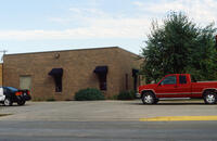
902 Park Street in Grinnell, Iowa, where the Baumann dental offices are located. Drake Community Library (Grinnell, Iowa) Archives. Martzahn City Planning Slides, p.12, slide 17.
-
Date Created
-
2001
-
PID
-
grinnell:30249
-

-
Title
-
Abandoned Cars
-
Description
-
Abandoned cars in Grinnell, Iowa, 1973. Drake Community Library (Grinnell, Iowa) Archives. Chamber of Commerce Slides, p.9, slide 10.
-
Date Created
-
1973
-
PID
-
grinnell:19318
-

-
Title
-
Aerial View Of Downtown Grinnell 1940s
-
Description
-
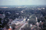
Aerial view of downtown Grinnell in the 1940s. The photo looks to the east. The bottom left corner is approximately the intersection of 5th Avenue and Spring Street and extends south along West Street to approximately 3rd Avenue. The Old Stone Church, Central Park, the Glove Factory and many other buildings are visible. Drake Community Library (Grinnell, Iowa) Archives. Views of Grinnell, Aerial Images. Collection 17-5.
-
Date Created
-
1940
-
PID
-
grinnell:27169
-
-
Title
-
Aerial View of 4th Avenue and State Street
-
Description
-
Aerial photograph looking north from the intersection of 4th Avenue, State Street and the railroad tracks in Grinnell, Iowa, in 1967. Grinnell Motor Company is visible in the center of the photo with Brand Apartments just to the left.
-
Date Created
-
1967
-
PID
-
grinnell:6404
-
-
Title
-
Aerial View of East Street and 4th Avenue 1970s, Aerial View of East Street and Fourth Avenue
-
Description
-
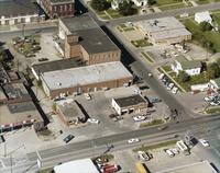
Aerial photo of the intersection of East Street and 4th Avenue in Grinnell, Iowa, in the early 1970s, looking west-northwest. Visible along the bottom of the photograph, from left to right, are Russ's Feed, McCurry Cafe, Pioneer gas station and Fina Fuel. Across the street is the Goodyear parking lot. Also visible are the Spaulding Manufacturing buildings and the the police station. Drake Community Library (Grinnell, Iowa) Archives. Views of Grinnell, Aerial Images. Collection 17-5.
-
Date Created
-
1970
-
PID
-
grinnell:27168
-
-
Title
-
Aerial View of Grinnell Looking West along the Railroad Tracks
-
Description
-
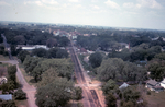
Aerial photograph looking west along the railroad tracks from approximately High Street in Grinnell, Iowa, in 1967. The railroad depot is visible in the center of the picture and just to the right of the depot the Monroe Hotel is visible. The Spaulding smokestack is visible in the background to the left.
-
Date Created
-
1967
-
PID
-
grinnell:6405