- * (x)
- Grinnell College. Center for the Humanities (supporting host) (x)
- Students (x)
- yearbook (x)
- Community Contributions (x)
- 1950s (x)
- Search results
-
-
Title
-
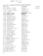
Address Roster of the 335th Signal Company
-
Description
-
Address roster of personnel in the 335th Signal Company in 1945. The list contains the names and home towns of the men in the picture of the company (see https://digital.grinnell.edu/islandora/object/grinnell%3A6516)
-
Date Created
-
1945
-
PID
-
grinnell:6515
-
-
Title
-
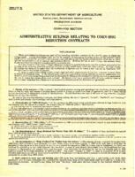
Administrative Rulings Relating to Corn-Hog Reduction Contracts
-
Description
-
U.S. Department of Agriculture Agricultural Adjustment Administration Corn-Hog Section rulings on corn-hog reduction contracts. Form C.H. 20, dated December 19, 1933. Printed by the U.S. Government Printing office, document number 16-1629.
-
Date Created
-
1934
-
PID
-
grinnell:30056
-

-
Title
-
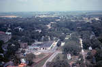
Aerial Photo of Grinnell 1967
-
Description
-
Aerial photo of downtown Grinnell taken by Dave Heise from a helicopter in July 1967 during Ridiculous Days. This view looks to the southeast. The intersection at the bottom of the image, just to the right of center, is the intersection of 6th Avenue and West Street.
-
Date Created
-
1967
-
PID
-
grinnell:6230
-
-
Title
-
Aerial View of 4th Avenue and State Street
-
Description
-
Aerial photograph looking north from the intersection of 4th Avenue, State Street and the railroad tracks in Grinnell, Iowa, in 1967. Grinnell Motor Company is visible in the center of the photo with Brand Apartments just to the left.
-
Date Created
-
1967
-
PID
-
grinnell:6404
-

-
Title
-
Aerial View of Bailey Homestead
-
Description
-
Aerial view of the James Bailey homestead west of Grinnell, Iowa on Eleventh Avenue. Photo ca. 1960s.
-
Date Created
-
1960
-
PID
-
grinnell:5830
-

-
Title
-
Aerial View of Downtown Grinnell
-
Description
-
Aerial photograph of downtown Grinnell, Iowa, looking southeast from the intersection of 6th Avenue and West Streets in 1967. Lake Nyanza is visible in the upper right corner of the photo.
-
Date Created
-
1967
-
PID
-
grinnell:6408
-

-
Title
-
Aerial View of Downtown Grinnell
-
Description
-
Aerial photograph of downtown Grinnell, Iowa, looking north along Broad Street from Central Park in 1967. Many Grinnell landmarks are visible: Merchants National Bank, Cunningham Drug, Stewart Library, the post office, Saint Mary's Catholic Church, the Colonial Theatre, Spaulding House.
-
Date Created
-
1967
-
PID
-
grinnell:6406
-

-
Title
-
Aerial View of Downtown Grinnell
-
Description
-
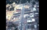
Aerial photograph of downtown Grinnell, Iowa, looking north along Main Street from approximately 3rd Avenue in 1967.
-
Date Created
-
1967
-
PID
-
grinnell:6407
-
-
Title
-
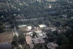
Aerial View of Grinnell College Campus
-
Description
-
Color aerial photograph of the Grinnell College campus looking east along 8th Avenue in 1967. The science building is at the bottom center of the photo. To the right of that is the Men's Gymnasium (called Women's Gymnasium after 1942). The east campus dormitories and Saint John's Lutheran Church are visible near the center of the photo.
-
Date Created
-
1967
-
PID
-
grinnell:6400
-
-
Title
-
Aerial View of Grinnell Looking North
-
Description
-
Aerial photo of downtown Grinnell taken by Dave Heise from a helicopter in July 1967 during Ridiculous Days. This view looks north on Main Street from Commercial Street to 6th Avenue.
-
Date Created
-
1967
-
PID
-
grinnell:6231