- * (x)
- Other (x)
- 1971 (x)
- Grinnell (Iowa) (x)
- Community Contributions (x)
- Education (x)
- Search results
-
-
Title
-
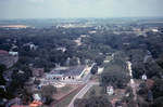
Aerial View of 4th Avenue and State Street
-
Description
-
Aerial photograph looking north from the intersection of 4th Avenue, State Street and the railroad tracks in Grinnell, Iowa, in 1967. Grinnell Motor Company is visible in the center of the photo with Brand Apartments just to the left.
-
Date Created
-
1967
-
PID
-
grinnell:6404
-

-
Title
-
Aerial View of Bailey Homestead
-
Description
-
Aerial view of the James Bailey homestead west of Grinnell, Iowa on Eleventh Avenue. Photo ca. 1960s.
-
Date Created
-
1960
-
PID
-
grinnell:5830
-

-
Title
-
Aerial View of Downtown Grinnell
-
Description
-
Aerial photograph of downtown Grinnell, Iowa, looking southeast from the intersection of 6th Avenue and West Streets in 1967. Lake Nyanza is visible in the upper right corner of the photo.
-
Date Created
-
1967
-
PID
-
grinnell:6408
-

-
Title
-
Aerial View of Downtown Grinnell
-
Description
-
Aerial photograph of downtown Grinnell, Iowa, looking north along Broad Street from Central Park in 1967. Many Grinnell landmarks are visible: Merchants National Bank, Cunningham Drug, Stewart Library, the post office, Saint Mary's Catholic Church, the Colonial Theatre, Spaulding House.
-
Date Created
-
1967
-
PID
-
grinnell:6406
-

-
Title
-
Aerial View of Downtown Grinnell
-
Description
-
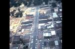
Aerial photograph of downtown Grinnell, Iowa, looking north along Main Street from approximately 3rd Avenue in 1967.
-
Date Created
-
1967
-
PID
-
grinnell:6407
-
-
Title
-
Aerial View of Grinnell Looking North
-
Description
-
Aerial photo of downtown Grinnell taken by Dave Heise from a helicopter in July 1967 during Ridiculous Days. This view looks north on Main Street from Commercial Street to 6th Avenue.
-
Date Created
-
1967
-
PID
-
grinnell:6231
-
-
Title
-
Aerial View of Grinnell Looking West along the Railroad Tracks
-
Description
-
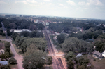
Aerial photograph looking west along the railroad tracks from approximately High Street in Grinnell, Iowa, in 1967. The railroad depot is visible in the center of the picture and just to the right of the depot the Monroe Hotel is visible. The Spaulding smokestack is visible in the background to the left.
-
Date Created
-
1967
-
PID
-
grinnell:6405
-

-
Title
-
Aerial View of Newburg Stock Pens
-
Description
-
An aerial view of stock pens and farm outbuildings, possibly in the Newburg, Iowa area. A railroad track runs along the right side of the picture.
-
Date Created
-
1920
-
PID
-
grinnell:12007
-

-
Title
-
Aerial View of Puls Farm
-
Description
-
Aerial view of the farm and home of Walter and Dorothy H. Puls in Section 29, Sheridan Township, Poweshiek County, Iowa. Walter and Dorothy owned this farm from 1983 through 2006. Their son, Donald Puls, resided at the farm until 2005. Legal description of the farm: NE 1/4 29-81-15 and 120 ac N 1/2 28-81-15. Drake Community Library (Grinnell, Iowa) Archives. Pamphlet file. Poweshiek County (Iowa) -- History -- Sheridan Township.
-
Date Created
-
2000
-
PID
-
grinnell:11575