- Business (x)
- C.U. Williams Photoette (author) (x)
- Poweshiek County (Iowa) (x)
- 1990s (x)
- Search results
-

-
Title
-
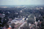
Aerial View Of Downtown Grinnell 1940s
-
Description
-
Aerial view of downtown Grinnell in the 1940s. The photo looks to the east. The bottom left corner is approximately the intersection of 5th Avenue and Spring Street and extends south along West Street to approximately 3rd Avenue. The Old Stone Church, Central Park, the Glove Factory and many other buildings are visible. Drake Community Library (Grinnell, Iowa) Archives. Views of Grinnell, Aerial Images. Collection 17-5.
-
Date Created
-
1940
-
PID
-
grinnell:27169
-
-
Title
-
Aerial View of 4th Avenue and State Street
-
Description
-
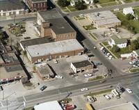
Aerial photograph looking north from the intersection of 4th Avenue, State Street and the railroad tracks in Grinnell, Iowa, in 1967. Grinnell Motor Company is visible in the center of the photo with Brand Apartments just to the left.
-
Date Created
-
1967
-
PID
-
grinnell:6404
-

-
Title
-
Aerial View of Downtown Grinnell
-
Description
-
Aerial view of Grinnell, Iowa, possibly taken in 1895 from the water standpipe at the corner of Second Avenue and Main Street. In the foreground appears to be a lumber yard. Mid-photo the Rock Island railroad lines run east and west. Next you see the rear facades of the buildings on Commercial Street between Main Street and Broad Street. Central Park is visible to the far right and the Congregational Church (the Old Stone Church) is visible to the north of that. Drake Community Library (Grinnell, Iowa) Archives. Miscellaneous photographs. Collection #17-5, Views of Grinnell.
-
Date Created
-
1895
-
PID
-
grinnell:12227
-

-
Title
-
Aerial View of Downtown Grinnell
-
Description
-
Aerial view of Grinnell, Iowa, taken in October 1895 from the water standpipe at Second Avenue and Main Street. This view looks to the northwest. In the upper left the Spaulding carriage factory is visible. In the foreground are grain bins and an elevator. In the bottom right corner, the tracks in the road define Main Street. In the upper right, Grinnell House, and early hotel is visible and beyond that is Preston and Proctor opera house. Drake Community Library (Grinnell, Iowa) Archives. Miscellaneous photographs. Collection #17-5, Views of Grinnell.
-
Date Created
-
1895
-
PID
-
grinnell:12228
-

-
Title
-
Aerial View of Downtown Grinnell
-
Description
-
Aerial photograph of downtown Grinnell, Iowa, looking southeast from the intersection of 6th Avenue and West Streets in 1967. Lake Nyanza is visible in the upper right corner of the photo.
-
Date Created
-
1967
-
PID
-
grinnell:6408
-

-
Title
-
Aerial View of Downtown Grinnell
-
Description
-
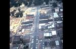
Aerial photograph of downtown Grinnell, Iowa, looking north along Broad Street from Central Park in 1967. Many Grinnell landmarks are visible: Merchants National Bank, Cunningham Drug, Stewart Library, the post office, Saint Mary's Catholic Church, the Colonial Theatre, Spaulding House.
-
Date Created
-
1967
-
PID
-
grinnell:6406
-

-
Title
-
Aerial View of Downtown Grinnell
-
Description
-
Aerial photograph of downtown Grinnell, Iowa, looking north along Main Street from approximately 3rd Avenue in 1967.
-
Date Created
-
1967
-
PID
-
grinnell:6407
-
-
Title
-
Aerial View of East Street and 4th Avenue 1970s, Aerial View of East Street and Fourth Avenue
-
Description
-
Aerial photo of the intersection of East Street and 4th Avenue in Grinnell, Iowa, in the early 1970s, looking west-northwest. Visible along the bottom of the photograph, from left to right, are Russ's Feed, McCurry Cafe, Pioneer gas station and Fina Fuel. Across the street is the Goodyear parking lot. Also visible are the Spaulding Manufacturing buildings and the the police station. Drake Community Library (Grinnell, Iowa) Archives. Views of Grinnell, Aerial Images. Collection 17-5.
-
Date Created
-
1970
-
PID
-
grinnell:27168
-
-
Title
-
Aerial View of Grinnell Looking North
-
Description
-
Aerial photo of downtown Grinnell taken by Dave Heise from a helicopter in July 1967 during Ridiculous Days. This view looks north on Main Street from Commercial Street to 6th Avenue.
-
Date Created
-
1967
-
PID
-
grinnell:6231